| Home | Maps & Guides | Campaigns | Local History | Local Information |
About Croydecycle
Croydecycle produces writing and images related to Croyde and walking or cycling in the South-West. North Devon has some of the finest cycling in the country. The Tarka Trail by Braunton is hard to beat and there is a network of quiet back roads inland. The area offers rewarding coastal walks, often with spectacular views. Discover local nature, culture and history and experience why this is such a fine place to live. Village pubs and shops are there to provide a welcome break. Forget the car, breathe quality air, feel the glow of exercise. It was you and you alone that got you from A to B. Enjoy!
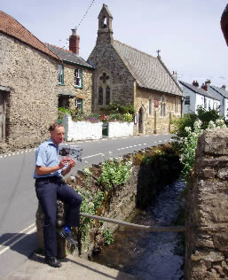
Croydecycle is run by Mike Harrison from his home at Rose Cottage. He believes that in most cases it is the bike that is the best way to get around North Devon and walking is the only real way to appreciate the landscape. Croydecycle began in June 2005, since when there has been a flow of information of use to cyclists and walkers, whether local travellers or visitors.
See maps page for information on these maps:
Walking maps at 1:12,500 – Nineteen maps cover the North Devon Coast and Exmoor (Watchet to Bude), nine maps cover South Hams coast (Plymouth to Brixham) and fourteen maps cover East Devon/Dorset coast (Exeter to Studland). In some places there are additional choices such as Lynton & Lynmouth with surroundings either east or west. For long distance walkers there is a Coast Path map that covers Minehead to Watermouth, arranged in strips at 1:15,000.
2023/2024 Four Dartmoor maps.
Cycle maps – Braunton/Ilfracombe 1:30,000; Exmouth/Sidmouth 1:30,000; Totnes/Dartmouth 1:30,000; Kingsbridge 1:30,000. Devon Coast to Coast Cycle Route 27 at 1:60,000. At appropriate scales with comments on cycle possibilities and information.
South West at 1:100,000 – maps for cyclists or drivers. The six maps are: Cornwall west; Cornwall east; North Devon; South Devon; East Devon/Exeter; Exmoor/Taunton. Maps show roads, places, relief, facilities pretty much everything a road cyclist would hope to find on a map at possibly the ideal scale.
Contact Croydecycle:
email:
tel: 01271 891160
post: Croydecycle,
Rose Cottage,
31 St Mary's Road,
Croyde,
Braunton,
Devon
EX33 1PF